listen live
Randy Houston

ON AIR STAFF
Randy Houston
full schedule

on the air
broken clouds 64° Apr 19's Weather
Clouds
HI: 65° LOW: 60°
Your Forecast

News

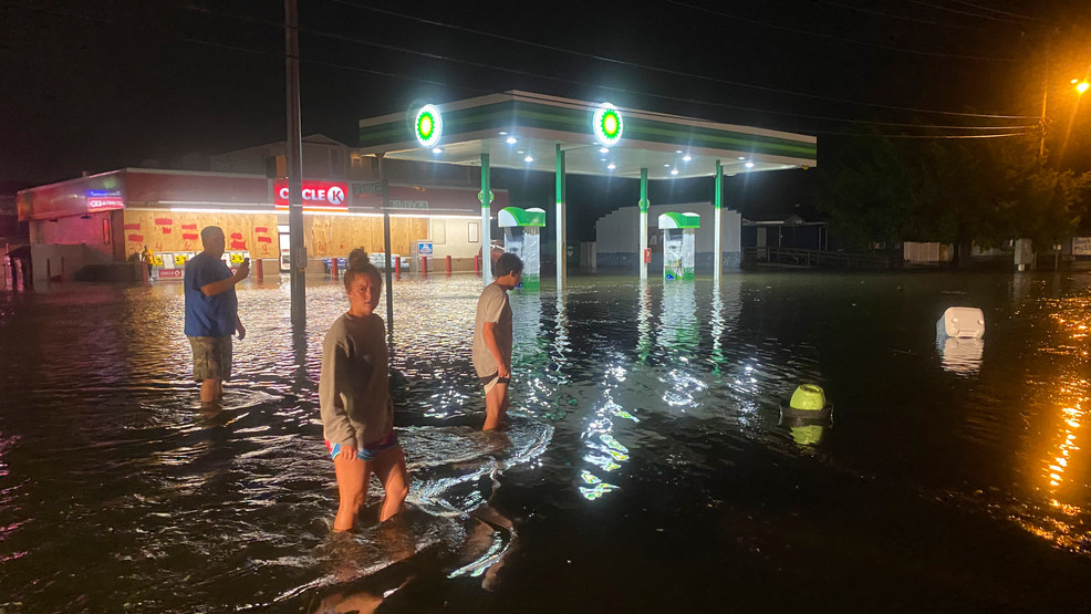
Conditions slowly getting back to normal across much of Henderson County, with the torrential rain, out of these severe storms that pounded our area at the end of the week.

A day after heavy rains and storms pummeled the region, residents are about to get a relative break, and welcome change from the wet weather, but signs of its aftermath remained even during the day on, Saturday.

There were some scattered, occasional showers hitting the area late Saturday afternoon before ending in the evening, but the next few days should be dry.
According to Jeffrey Taylor at the National Weather Service, the Asheville airport broke the daily record on Friday, while totals in Henderson County varied by location.
“The Asheville airport got 5.92 inches in 24 hours, breaking the record,” he said. “In Henderson County, there was a pretty good range. There was a swath close to 5 inches in the northwest part of the county. As you go to the southeast, it drops down to 2-3 inches. Most of the county got at least 2 inches.”
Rivers and parks
According to a statement from the National Weather Service, a river flood warning continues until 6:45 a.m. for the French Broad River at Blantyre affecting Henderson and Transylvania Counties and the French Broad River near Fletcher affecting Buncombe and Henderson Counties. The statement noted that runoff from previous heavy rain will result in the rivers remaining above flood stage.
The French Broad River at Blantyre was at 21.1 feet as of 3 p.m. Saturday (flood stage is at 16 feet), but it is expected to subside below flood stage early Monday. Additionally, the Little River at Merrill Road in Transylvania County reached a high point of 10.96 at 4:30 p.m. Friday (flood stage is 9 feet), but it was down to 9.62 at 3 p.m. on Saturday.
Meanwhile, the storms and heavy rain left many parks and other activity areas a soggy mess.


Photo courtesy of Blue Ridge Now.com

Area farmers have been hit pretty hard, and Friday's heavy rain was certainly no exception, continuing in that too-wet trend, thats been going on for a year now, according to Henderson County Extension Director Dr. Terry Kelley.

Back last year (May 2018) when a big rain event, and the ongoing trend of practically solid wet weather, that has given growers all over the county problems, from washed out roads to fields too wet to even work in.

The county has indeed seen periods when conditions were favorable for a drying trend, but then it all starts again.

Apple growers in Henderson County, and those with other crops have started their spraying treatments which rain and moisture can of course disrupt. Wetter weather creates, and enhances better environment for diseases.

Hopefully the spigot will eventually normalize, with not so much rain, and wet weather going into the upcoming Summer months, as we have had previously.

A blaze broke out at The Walmart Supercenter at 250 Highlands Square Drive early this morning. The store was quickly evacuated when firefighters responded to a freezer fire.

Firefighters received a call at around 4:30 a.m. involving a refrigeration unit that had caught on fire, according to Hendersonville Fire Chief Joseph Vindigni.

The store, which is open 24 hours a day, had to be evacuated.

Firefighters used an extinguisher for the fire, Vindigni said. However, the fire caused billows of smoke throughout the building.

Friefighters assisted with ventilating the building, which took a long time, Vindigni said, due to the size of the building as well as the torrential rain.

The scene was cleared by about 8:30 a.m.

Dana, Edneyville and Valley Hill fire departments were on hand and assisted, along with the Hendersonville Police Department, Henderson County Rescue Squad and EMS.

The Bill Moore Community Park in Fletcher is closed today because of the weather, and they hope to open, and resume service tomorrow.

Sylvia Hatchell Is Out at U.N.C. After Inquiry Supports Team’s Complaints

Sylvia Hatchell coached the University of North Carolina women’s basketball team for 33 years.

By Marc Tracy and Alan Blinder

April 19, 2019

Sylvia Hatchell, the longtime women’s basketball coach at the University of North Carolina, stepped down after an investigation found she had made “racially insensitive” comments and pressured injured players to compete, the university announced late Thursday night.

Hatchell, who is fifth in career coaching victories in women’s basketball, was placed on leave this month, days after parents of several players met with the university’s athletic director, Bubba Cunningham, to complain about comments she had made that players interpreted as racist, including a warning that a bad loss could lead to “nooses.”

The report “found issues that led us to conclude that the program needed to be taken in a new direction,” Cunningham said in a statement.

Hatchell, 67, did not address the accusations in the statement, which described her departure as a resignation. Instead, it said she had been contemplating this move since she was given a diagnosis of leukemia several years ago.

FILED BY ROBERT FRANKLIN/ASSOCIATED PRESS

A band of heavy rain showers and embedded thunderstorms are roaring through the mountains of the Western Carolinas. The primary threat from these showers and storms will be from very heavy rainfall leading to that localized flash flooding in low lying areas. Brief, damaging wind gusts can still be a possibility as these storms continue. Tomorrow will be unsettled, much cooler, with a few showers. Easter Sunday will turn mostly sunny with a milder afternoon.

Currently at weather observation station, WHKP has received 2.5 in. of rain as of 1:25PM on Friday afternoon.


Heavy rain continues to wreak havoc on the residents of Henderson County, and the flooding has had a significant impact on low-lying areas, all those flood prone spots. Currently at this time there are 1,477 outages in Henderson County, putting much emphasis on the town of Flat Rock, especially in the Greenville Hwy vicinity. These outages are a result of fallen trees, and there is no estimated time on when the power will be restored, that according to info submitted to WHKP news. Stay indoors, and keep us close by for the latest info.

UPDATE at 10:30 a.m.: Emergency Services Director Jimmy Brissie said they’ve taken a number of calls this morning for trees and power lines down.
The county is also starting to see some flash flooding along Mud Creek and Cane Creek.
Greenville Highway is closed near St. John in the Wilderness. A tree has been reported down in the area, and more than 1,000 Duke Energy customers are without power in Flat Rock.
Nearly 700 customers are without power along U.S. 64 in the Edneyville area.
The Beverly Hanks Center and Seventh Avenue in front of DaVita Dialysis are closed, the Hendersonville Police Department said.
The following roads are also closed due to downed trees or flooding: U.S. 64 (Chimney Rock Road) near Apple Valley Travel Park, tree down; Jackson Road between Howard Gap Road and Coffee Lane; River Road at Etowah School Road; Timberlane Drive off Old Highway 64.
A tornado watch has been issued for Polk and Rutherford counties and the Piedmont and Upstate South Carolina.
Thunderstorms, heavy rain soaking Henderson County

A wet morning continues in Henderson County as thunder and heavy rain move through the area.
A hazardous weather outlook has been issued by the National Weather Service for Western North Carolina, the Piedmont and Upstate South Carolina.
“Isolated severe thunderstorms capable of producing locally damaging wind gusts and isolated brief tornadoes will be possible, especially across the Piedmont, and especially in the late morning and afternoon. In addition, localized excessive rainfall may cause flash flooding of small streams and urban areas,” the NWS says.
Winds of 14 to 16 mph is expected today, with gusts as high as 29 mph. New rainfall amounts between 1 and 2 inches possible, the NWS says.
About 1,000 customers are without power in Flat Rock near St. John in the Wilderness, and a tree has been reported down in that area.
A severe thunderstorm warning was in effect until 10:15 a.m. and a flood advisory is in effect until 9:15 p.m.
The rain should continue until at least 2 a.m., with a low around 41. South southwest winds of 9 to 15 mph, with gusts as high as 28 mph, are expected overnight.
There’s a 50-percent chance of showers Saturday, with a high near 51.

More strong thunderstorms are headed to the Carolinas, bringing the potential for tornadoes and heavy rain, the National Weather Service says.
A line of strong to severe thunderstorms will move east across the Carolinas on Friday, forecasters say. “A few of these storms may be capable of producing damaging winds and tornadoes. Very heavy rainfall is likely,” the Weather Service in Raleigh warned.

All of North and South Carolina could see impacts from the storms, but central and eastern North Carolina, along with South Carolina’s Pee Dee and Grand Strand regions, are at particular risk for severe weather. The Weather Service says the storms should move through central and eastern parts of the Carolinas between 1 p.m. and 1 a.m. Friday. The strongest storms could produce damaging straight-line winds and isolated tornadoes. Flooding rainfall is also possible,” the Weather Service said Wednesday morning.


The Interstate 95 corridor could see some of the heaviest rains with at least 1.5 inches predicted, according to the Weather Service’s Wilmington office. Parts of northeast South Carolina, including the Myrtle Beach area, could also see more than 1.5 inches of rain, according to the Weather Service.


The Wilmington and Myrtle Beach areas could see damaging winds and “a few tornadoes,” the Weather Service said.

NWS forecasters warned: “Thunderstorms may be severe; will move across the Cape Fear region Friday afternoon/evening. Storms will exit Friday night into early Saturday morning.”
The timing will be earlier for western North Carolina and the South Carolina Upstate. The band of storms will move into the Carolinas starting early Friday morning. Some of the storms could be severe, the Weather Service in Greenville, South Carolina, said.


Friday
Showers and possibly a thunderstorm, mainly before 5pm, then a chance of showers and thunderstorms after 5pm. High near 66. South wind 11 to 16 mph, with gusts as high as 28 mph. Chance of precipitation is 100%. New rainfall amounts between 1 and 2 inches possible.

Friday Night
A chance of showers and thunderstorms before 11pm, then a chance of rain, mainly between 11pm and 5am. Mostly cloudy, with a low around 41. West wind 5 to 15 mph, with gusts as high as 25 mph. Chance of precipitation is 40%. New precipitation amounts between a tenth and quarter of an inch, except higher amounts possible in thunderstorms.

Saturday
A slight chance of rain before 9am, then a chance of showers after 9am. Mostly cloudy, with a high near 52. South wind 9 to 11 mph, with gusts as high as 18 mph. Chance of precipitation is 50%.

Saturday Night
A slight chance of showers before 9pm, then a slight chance of rain between 9pm and 10pm. Mostly cloudy, with a low around 38. Chance of precipitation is 20%.

Sunday
Sunny, with a high near 69.

Isolated severe thunderstorms capable of producing locally damaging wind gusts and isolated brief tornadoes will be possible, especially across the Piedmont during the daylight hours Friday,” the Weather Service said. There could also be local flash flooding in streams and urban areas.

Friday’s storms will follow about the same pattern as the storms a week before, according to the Weather Channel. The line of severe weather will start in the Plains and the Midwest on Wednesday and sweep across the South to the East Coast over the coming days, the Weather Channel forecasts, bringing heavy rain, wind, and the possibility for hail and tornadoes with it.


This Week at NCDOT: Bicycle Helmets and Watch for Me NC

RALEIGH – The following are highlights from this week at the N.C. Department of Transportation. The stories below are also featured in NCDOT Now, the department's weekly newscast.

Bicycle Helmet Initiative

A record number of children, more than 3,300, across the state will be receiving lifesaving bicycle helmets through the department’s Bicycle Helmet Initiative. The program is part of ongoing efforts to reduce bicycle injuries and deaths in North Carolina.

Helmets save lives. While less than half of all children typically wear a helmet while biking, they can reduce the risk of severe brain injuries by nearly 90 percent.

NCDOT uses funds from the sale of the “Share the Road” specialty license plate to pay for the helmets, which are given to underprivileged children.

New Watch for Me NC Communities

In addition to the helmet initiative, the department’s Watch for Me NC program is also working to reduce pedestrian and bicyclist fatalities and injuries.

Started in 2012, the program educates and engages the community in working to keep people safe on the road. Law enforcement officers are trained in ways to communicate, improve and enforce safety rules in their area.

This year, 10 new communities are joining 29 existing partners across the state, helping to increase the program’s reach statewide. They are:
• Beaufort (Carteret County)
• Beech Mountain (Watauga County)
• Belmont (Gaston County)
• Blowing Rock (Watauga County)
• Farmville (Pitt County)
• Hertford (Perquimans County)
• Roanoke Rapids (Halifax County)
• Shelby (Cleveland County)
• Wendell (Wake County)
• Winston-Salem (Forsyth County)

Learn more at WatchforMeNC.org.

NC Moves 2050 Survey

As modern technology and changing demographics impact North Carolina’s transportation system, your input is needed more than ever.

Help guide the state’s transportation future by taking a quick survey as part of the NC Moves 2050 Plan.