

Heavy rain, damaging wind, and even a shot of wintry weather will return to Western North Carolina (WNC) during the first half of the new week.
Monday will be the last quiet day before the next weather-maker, with a mix of sun and clouds and seasonal temperatures for January.
A powerful low-pressure system moves into the southern U.S. Monday, bringing a threat of severe weather to the southern Gulf states. That system aims at WNC on Tuesday.
Showers lift from the southwest starting late Monday, turning widespread overnight.
Temperatures could briefly drop to the freezing mark by early Tuesday morning, which could result in some light icing for parts of the mountains before sunrise. This won't happen everywhere, and the threat for icy conditions will be short-lived.
More widespread impacts to the Tuesday morning commute will be moderate to heavy rain, making for wet roads and slow travel.
Rain will continue to fall through Tuesday morning, adding up quickly where the heavier rain bands set up. After several hours of steady rainfall, showers will taper off during the afternoon hours.
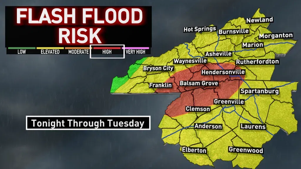
Most rainfall totals could add up to 1-3 inches, but higher totals could be found along the southern Blue Ridge Escarpment. Rainfall could reach 4-5 inches in these areas.
Flooding threats will increase along creeks, rivers, streams, and other low-lying areas, prompting a Flood Watch for Rutherford, Polk, Henderson, Transylvania, Macon, and Southern Jackson counties.
Aside from rain, this system will bring howling wind gusts. Winds will increase Monday night and continue through Tuesday. Gusts on the higher ridge tops will reach up to 70 mph at times. Asheville and surrounding valleys gust to 50 mph.
There's enough moisture left over to squeeze out some snow on the backside of this system. This could happen late Tuesday through early Wednesday morning. Any accumulation looks to favor the higher elevations along the Tennessee state line.
Thursday will be quiet and dry, but our next moisture maker moves in later in the week.
STORY & PHOTO COURTESY OF ABC 13 WLOSHeavy rain, strong wind, possible icing forecasted for parts of WNC | WLOS